| 公司: | 麻省理工学院 可感知城市实验室 | 类型: | 建筑 |
|---|---|---|---|
| 地区: | 巴西 | 标签: | 街道改造 |
研究使用激光扫描数据来分析巴西著名的非正式定居点之一的建筑逻辑
全球城市化的趋势并不局限于繁华的市中心区和总体规划的发展:在全世界大约40亿居住在城市的人中,有近10亿人居住在没有官方城市规划的非正式定居点。这些住区是自发和竞争性地建造的,从而形成了复杂的城市形态。生活在非正规住区的人在很大程度上被排除在城市基础设施和服务之外,使他们面临各种公共卫生和安全挑战。但由于世界上爆炸性的城市人口超过了官方可负担住房的供应,他们继续吸收新一代的居民。
Study uses laser scanning data to analyze the architectural logic of one of Brazil’s famous informal settlements
The global trend of urbanization is not limited to shining downtown districts and masterplanned developments: of the roughly 4 billion people who live in cities worldwide , almost 1 billion reside in informal settlements constructed without official 1 urban planning . These settlements are built spontaneously and competitively, resulting 2 in a complex urban morphology. People living in informal settlements are largely excluded from city infrastructure and services—exposing them to a variety of public health and security challenges—but they continue to absorb new generations of residents as the world’s exploding urban population outpaces the availability of official affordable housing.
(*分析成果链接 URL of the project:https://senseable.mit.edu/favelas/)
在巴西,这些非正式定居点被称为favelas,它们以密集、多层次的形式出现在里约热内卢等大城市的山丘上,与隔壁的规划社区形成鲜明的对比。空间上的复杂性使它们如此引人入胜,也使它们在很大程度上不被基于遥感的研究所影响:卫星图像、谷歌街景和开源地图只能提供对它们迷宫般的城市景观的一瞥。
In Brazil, these informal settlements are known as favelas, and they crop up in the hills of big cities like Rio de Janeiro in dense, multilayered forms that contrast starkly with the planned neighborhoods next door. The very spatial complexity that makes them so intriguing also makes them largely impervious to remote sensing-based research: satellite imagery, Google Street View, and open-source mapping only offer a glimpse into their labyrinthine cityscapes.
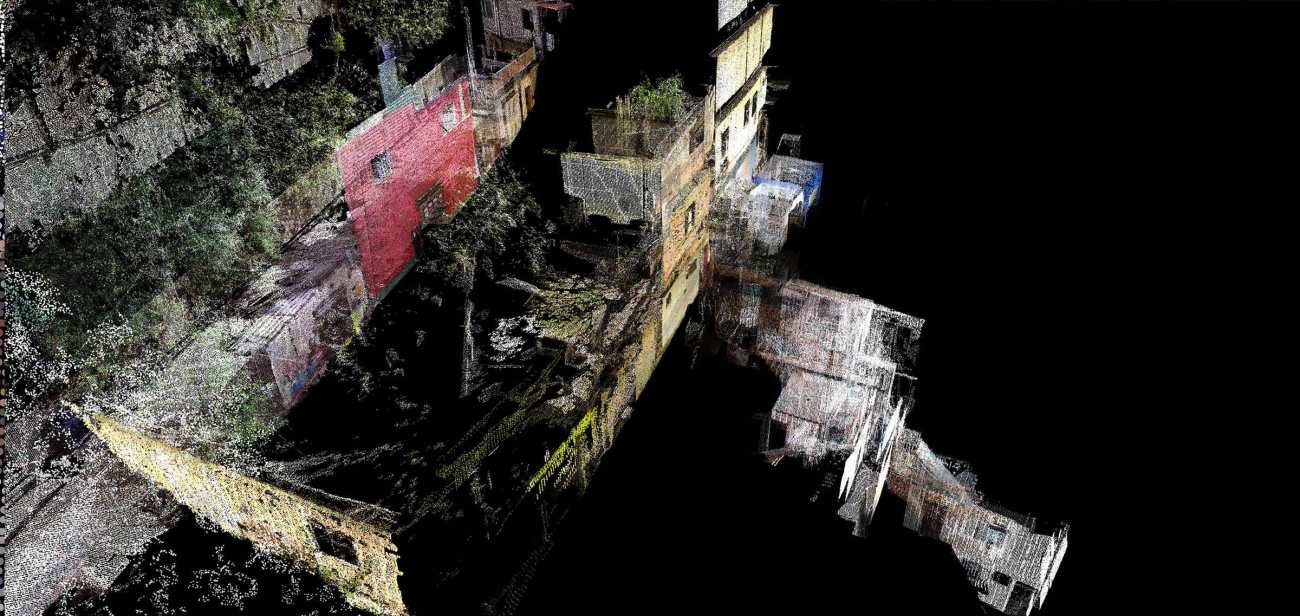
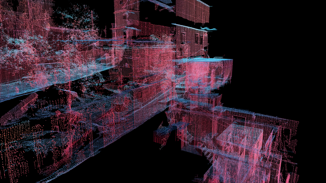
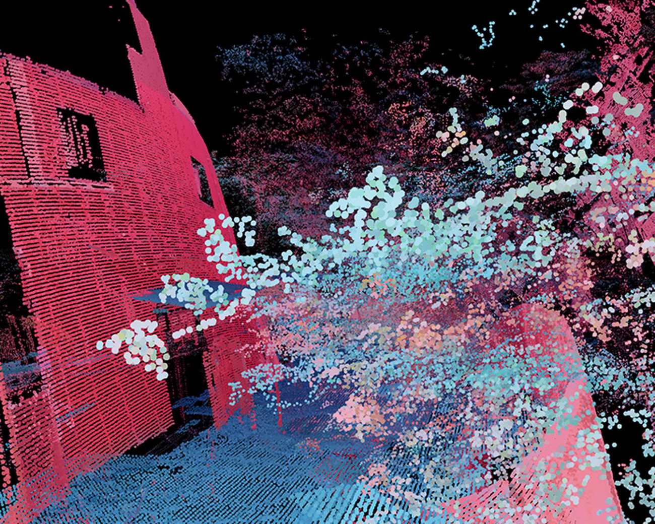
Favelas 4D是麻省理工学院可感知城市实验室与华盛顿法哈多合作的一个项目,它使用三维激光扫描技术来分析里约热内卢最大的贫民窟罗西尼亚的形态学。利用在贫民窟街道上拍摄的LiDAR(光探测和测距)的详细点云数据,研究人员能够以非常高的分辨率定量地描述这个复杂的建筑环境的形态变化。激光雷达使用激光脉冲来测量距离,将微小的点映射到空间的位置,以创建一个数据集,以令人难以置信的精度描述三维环境。
Favelas 4D, a project by MIT Senseable City Lab, in collaboration with Washington Fajardo, uses 3D laser scanning technology to analyze the morphology of Rocinha, the largest favela in Rio de Janeiro. Using detailed point cloud data from LiDAR (Light Detection and Ranging) scans taken at street level in the favela, researchers are able to quantitatively characterize morphological variation in this complex built environment at very high resolution. LiDAR uses a laser pulse to measure distances, mapping minuscule points to locations in space in order to create a dataset that describes a 3D environment with incredible precision.
LiDAR作为研究媒介的根本优势在于它对建筑环境的形式的精确描述。形式是研究非正规住区的一个富有成效的角度,因为它揭示了贫民窟无序建设的模式,阐明了不受约束的城市发展的趋势,并揭示了可操作的见解,可以为干预措施和政策提供信息,以改善这些环境的安全。贫民区因缺乏土地使用权而在财产交易方面挣扎,因其所处的不稳定地形而存在滑坡风险,因到达贫民区的基础设施和服务有限而导致水和空气质量下降;所有这些问题都与建筑环境的形状有关。然而,正如麻省理工学院可感知城市实验室主任和实践教授Carlo Ratti所观察到的,"尽管他们的环境充满挑战,贫民窟的居民已经开发了巧妙的和响应的方式来建立他们自己的城市系统。这种自下而上的规划过程和它所产生的复杂的建筑形式可以挑战设计城市的标准方式"。Favelas 4D从定量的角度研究城市形态,使用数据分析技术来描述和绘制罗西尼亚的形态动态。
The fundamental advantage of LiDAR as a research medium is its precise representation of the form of the built environment. Form is a productive angle for the study of informal settlements because it reveals patterns in the unregulated construction of the favela, illuminating the tendencies of unfettered urban development and revealing actionable insights that can inform interventions and policies to improve the safety of these environments. Favelas struggle with property trading due to the lack of land tenure, landslide risks due to the unstable terrain they occupy, and water and air quality due to the limited infrastructure and services that reach them; all of these issues are implicated in the shape of the built environment. However, as MIT Senseable City Lab director and professor of the practice Carlo Ratti observes, "Despite their challenging circumstances, favela residents have developed ingenious and responsive ways to build their own urban systems. This bottom-up planning process and the complex architectural forms it produces can challenge the standard way of designing cities." Favelas 4D examines urban form from a quantitative perspective, using data analysis techniques to describe and map the morphological dynamics at work in Rocinha.
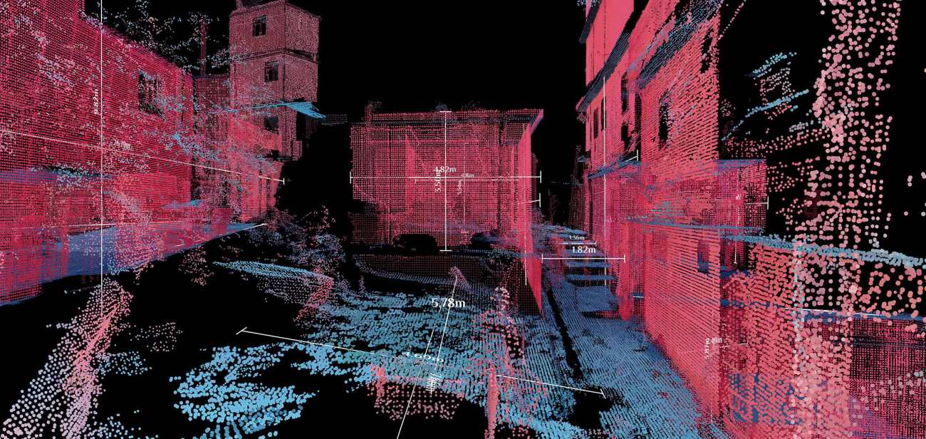
为了分析LiDAR数据,可感知城市实验室的研究人员开发了一个可扩展和自动化的程序,以测量贫民窟街道的形态质量。该分析在两种分辨率下运行,包括侧重于比较贫民窟不同街道的全球分析,以及解读街道内部形态变化的局部分析。我们考虑了五个形态学因素:街道宽度、街道高程、外墙密度、外墙高度差异和街道峡谷(外墙高度与街道宽度的比率)。利用分析结果,可以将0.5米分辨率的形态学信息直接映射到贫民窟的平面图上。
To analyze the LiDAR data, researchers at the Senseable City Lab have developed a scalable and automated process to measure the morphological qualities of streets in the favela. The analysis operates at two resolutions, including a global analysis focused on comparing different streets of the favela to one another, and a local analysis unpacking the variation of morphology within streets. Five morphological factors are considered: street width, street elevation, density of facades, variance in facade height, and street canyon (the ratio of facade height to street width). Using the results of the analysis, it is possible to map morphological information at a resolution of 0.5 meters directly onto the favela’s plan.
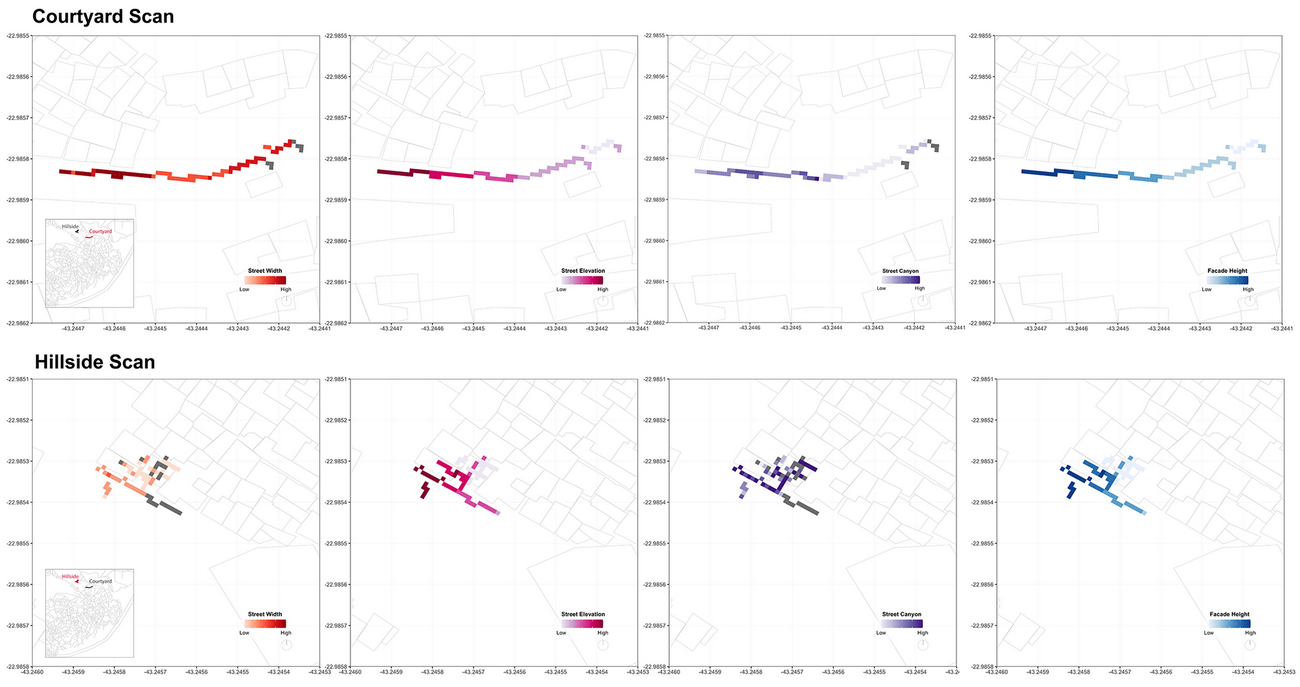
这两张扫描样本区的地图揭示了一些形态特征,如街道的夹角和拓宽以及高楼的集群。它们显示了本研究中所使用的扫描区域的可变形态,并提供了当整个贫民窟被扫描时可获得的宝贵信息类型的一瞥。里约热内卢的城市规划专员和该项目的合作者华盛顿法哈多对其为未来公共工程决策提供信息的潜力表示乐观。他解释说:"这些发现也可以用来制定规划策略,使正规城市对非正规住区更具包容性,或者引发对替代性建筑方式的研究,使城市环境对其不断增长的人口更具包容性和可负担性"。
These maps of the two sample scanning areas reveal morphological features like pinching and widening of streets and clusters of tall buildings. They show the variable morphology of the scanning area used in this research, and they offer a glimpse of the type of valuable information that will be available when the whole favela is scanned. Washington Fajardo, City Planning Commissioner for Rio de Janeiro and collaborator on the project, is optimistic about its potential to inform future public works decisions. He explains that "The findings could also be used to develop planning strategies that make the formal city more inclusive to informal settlements, or to spark research into alternative ways of building that make urban environments more accommodating and affordable to their growing populations."
这一分析有助于改善贫民窟的条件,同时也提出了关于发展实践和城市建设整体方法的问题。随着世界各地的非正规住区继续增长,研究人员和规划人员必须将其与全球城市未来的愿景相结合,既要学习他们独特的发展模式,又要改善他们获得正规城市化的好处。Favelas 4D通过调动LiDAR数据的独特功能和定量分析的启示,提供了一个三维形态分析如何帮助我们理解和塑造未来城市的例子,为这一目标做出了贡献。
This analysis contributes to the improvement of favela conditions and also raises questions about development practices and methods of city-building overall. As informal settlements around the world continue to grow, researchers and planners must integrate them with visions of the global urban future, both by learning from their unique development patterns and by improving their access to the benefits of formalized urbanism. Favelas 4D contributes to this goal by mobilizing the unique capabilities of LiDAR data and the revelations of quantitative analysis, offering an example of how 3D morphological analysis can help us understand and shape the cities of tomorrow.
Name: Favelas 4D
Designer: Mit Senseable City Lab
Director: Carlo Ratti
Project And Design Manager: Fábio Duarte
Project Lead, Research: Arianna Salazar Miranda
Visualization, Research: Guangyu Du
Research: Claire Gorman
Project Advisor: Washington Fajardo
更新日期:2021-04-27 15:21:46
非常感谢 麻省理工学院 可感知城市实验室 带来的精彩项目, 查阅更多Appreciations towards Mit Senseable City Lab for sharing wonderful work on hhlloo. Click to see more works!


